Home » The region's water supply » Services » Activities at Rocky Creek Dam
In This Section
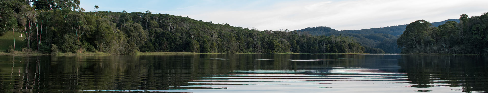
Activities at Rocky Creek Dam
Platypus boardwalk - closed until futher notice.
Dog owners are reminded that all dogs within the Rocky Creek Dam Rainforest and Water Reserve are to be on-leash at all times.
To download the brochure for Rocky Creek Dam click here.
Picnic spots
On the shores of Rocky Creek Dam, a grassy picnic area winds its way through stands of shady rainforest trees. There are picnic tables and gas barbecues, a sheltered picnic area and plenty of room for the kids to run around. Close to the carpark and amenities block there is an adventurous forest playground and the start of several walks. Along these walks you will find more beautiful picnic spots in hidden rainforest glades.
Other picnic spots can be found on the Catchment Forest Drive and Walks fact sheet, and there are picnic areas with barbecues and facilities at Rummery Park (camping area), Minyon Falls (with views on a clear day to the ocean from the top of the waterfall) and Minyon Grass (with spectacular views of Minyon Falls).
Short walks
There are five beautiful walks that you can do from Rocky Creek Dam picnic area.
- The Water Walk
60m wheelchair-accessible educational trail that takes you from the carpark to a lookout over the dam. - Water Dragon Walk
1.2km return, approximately 20 minutes, easy.
Walk near the water's edge, across the dam wall, up the hill to the lookout to view the spillway, and back. - Platypus Walk
1.5km, approximately 30 minutes, easy.
A relaxing walk through lightly forested land, across the pontoon bridge over Rocky Creek, along the elevated boardwalk beside the creek, through grassy glades, and back across the dam wall. - Cedar Walk
2.3km, approximately 50 minutes, easy - but could involve getting your feet wet!
This longer walk takes you to the edge of the Rainforest Reserve, through patches of forest, and into areas of rainforest regeneration. You will see forest at different stages of regeneration, cross Rocky Creek, the spillway and dam wall, as well as visit a small plantation of cabinet timbers. - Scrub Turkey Walk
6km return, 1.5 to 2 hours return from carpark to Catchment Forest Drive, medium difficulty.
Walk through the Rainforest Reserve, along any of the other walks, to the Cedar Walk on the other side of Rocky Creek. From here, walk into the Big Scrub rainforest of Nightcap National Park, to the Catchment Forest Drive, and back across the spillway and dam wall.
For a map and description of each walk from the picnic area, download the information sheet, Rous Rainforest and Water Reserve.
- The Big Scrub Loop
1.5km, approximately 45 minutes, moderate.
Accessible from the Catchment Forest Drive - this walk takes you through a beautiful area of Big Scrub lowland, subtropical rainforest and small creeks.
Longer walks
Other walks nearby, all accessible from the Catchment Forest Drive, include:
- Historic Nightcap Track
6.5km to edge of Tweed Valley escarpment, 13km return, or another 10km to Mt Nardi, moderate-hard.
The track starts at Peates Mountain and overlaps parts of the original trail used by travellers and postal workers between Lismore and Murwillumbah in the late 1800s and early 1900s. It takes you through many forest types and provides spectacular views to Mt Warning and the Border Ranges. Bush camping is permitted on this walk but visitors must use portable stoves and carry out their own rubbish. - Peates Mountain Trail
3km - 6km return, moderate.
This track connects Rummery Park camping area with Peates Mountain (once the site of a forestry fire tower). The trail passes through brushbox forest, warm temperate rainforest and blackbutt plantations closer to Rummery Park. - Rummery Road Walk
7.5km total. 2km to Rocky Creek crossing from Nightcap Range Road, easy-moderate.
Rummery Road is a management trail that connects Gibbergunyah Range Road in the west to Nightcap Range Road in the east. A walk past the eastern locked gate takes you through spectacular moist hardwood and rainforest to the Rocky Creek crossing and beautiful cascades. - Boggy Creek Trail
2km, approximately 45 minutes one way, easy.
This walk begins at Rummery Park and leads to Minyon Falls picnic area along beautiful Boggy Creek. It is also possible to take the alternative Eastern Boundary Trail from Minyon Falls picnic area back to Rummery Park, which also takes 45 minutes. This route contains some steep sections and offers views of Coopers Creek valley and Byron Bay on the coast. - Minyon Falls - The Minyon Loop
7.5km, 4.5 hours, moderate-hard.
Begins at Minyon Falls picnic area and takes visitors through changing vegetation to the base of the falls and along the escarpment edge. For visitors wishing to walk only to the base of Minyon Falls, the walk begins at Minyon Grass and is a 4km return walk taking around 2 hours. Both walks have steep climbs out of the valley floor.
For brief descriptions of each walk and a map of their locations, download the information sheet, Catchment Forest Drive and Walks.
The Catchment Forest Drive at Rocky Creek
Please note: The Catchment Forest Drive is subject to periodic review according to road conditions. Contact NSW National Parks and Wildlife Service for more information.
The Catchment Forest Drive allows you to drive on the roads on the very edge of the drinking water catchment area, from Rocky Creek Dam picnic area through some of the spectacular forests of the Nightcap Range. It is a 22km drive from the dam to Minyon Falls along a narrow dirt road suitable for two-wheel drives in dry weather.
For a map and detailed description of the drive, download the information sheet, Catchment Forest Drive and Walks.
The Water Walk
Be the eyes and ears for Australia’s climate researchers at Rocky Creek Dam. Use the recently developed ClimateWatch Guide on the Platypus Walk at the dam and help shape the country’s response to climate change by monitoring our local environment. Find out more on the ClimateWatch website or download the Recording Sheet and Field Guide prior to your walk.
This beautiful 60m walk winds its way from the carpark through the picnic area and rainforest to a lookout over the dam. On the way, you will discover new things about your place in the water cycle and how you can help care for our shared water supply.
You can learn about these things by reading the colourful sculptural signs complete with illustrations, photos and messages from our forest creatures. Each sign has a matching info sheet that you can take along on your walk to get a deeper understanding of each topic. You can download them here.
The Forest Playground
This adventure playground is nestled under rainforest trees in the picnic area at Rocky Creek Dam. Each part of the playground teaches kids and parents something different about the forest and the water cycle. Learning adventures include the Water Cycle slippery dip; the Cyclone spinner; and the Web of Life rope climbing pyramid. There is a range of playground equipment, suitable for kids over 3 years old.
Download our Forest Playground Games information sheet for a detailed description of each learning adventure.
Water Learning Place
This open-air building at Rocky Creek Dam picnic area has been created for picnics sheltered from the sun and rain, and as a learning centre to host classes and workshop groups.
The beautiful mural showcases Rocky Creek Dam as a 'jewel in the heart of the rainforest' and is an accurate teaching tool about the catchment. Rainwater collected from the roof is used to flush the toilets as a demonstration of water efficiency. Water poetry written by local residents is displayed with photos from the catchment area. A movable water level sign indicates how full the dam is at the time of your visit.
The Water Walk Guide: Rocky Creek Dam
This beautifully photographed and illustrated book is an important source of information about our place in the water cycle. It is also a guide to the Water Walk at Rocky Creek Dam, including educational experiences for your head, heart and hands. 82pages. Available free from the Rous County Council office in Lismore.
Njabai (Water): A Widjabul Creation Story
A traditional story told by Aboriginal custodians of our water catchments about the importance of water to all living things. Illustrated with Widjabul and other artwork, and historical photographs. This story is told in English and Bundjalung Nation dialect. 20 pages. Available free from the Rous County Council office in Lismore.